


Monitoring coral reefs has always been a blend of patience, precision, and passion. Divers once spent countless hours underwater with transect tapes and slates, carefully counting coral colonies or sketching rough outlines of nursery frames. These methods are still valuable, but as restoration programs expand and climate challenges intensify, marine biologists are turning to new technologies to make monitoring faster, more accurate, and more visually powerful. One of the most exciting tools reshaping how we observe and measure reefs is photogrammetry.
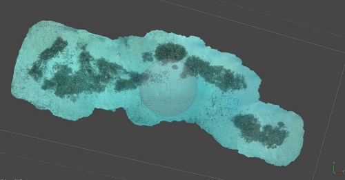
Imagine taking hundreds of overlapping photos of a coral nursery or a dive site from slightly different angles. A software then stitches these images together. The result? A detailed, high-resolution map, known as an orthomosaic, and even a 3D model of the reef or nursery structure.
What was once a flat series of photos becomes a living, measurable landscape. Every coral fragment, frame, or patch of bleaching can be located, measured, and tracked through time with centimeter-level precision.
For marine scientists and restoration managers, this means that the reef’s story, its recovery, its struggles, and its growth, can be told through data as well as through images.
Orthomosaic maps are more than beautiful images, they are powerful tools for decision-making. Here’s what they bring to coral reef stewardship:
- Tracking Growth and Health: By comparing orthomosaics over time, researchers can measure how much coral has grown, how many colonies survived, and where bleaching or disease appears.
- Mapping Spatial Patterns: Coral nurseries are often influenced by light, currents, and substrate type. Orthomosaics reveal which areas are thriving and which need attention.
- Assessing Restoration Success: When corals are outplanted to the reef, high-resolution models can document survival and integration with the natural reef community.
- Communicating Results: The 3D visuals are not just for scientists. They help resort guests, donors, and policymakers see progress, an essential part of building support for long-term restoration.
In short, orthomosaics turn reef monitoring into a story you can measure, visualize, and share.
Photogrammetry isn’t magic, it still depends on field skill and environmental conditions. Poor visibility, low light, or strong currents can reduce image quality. Underwater, GPS doesn’t work, so accurate scaling and alignment rely on reference markers and careful planning.
Processing can also be intensive, creating a detailed model of a large reef section can take days on a computer. Yet, as camera sensors, computing power, and software continue to improve, these challenges are becoming easier to overcome.
Many projects now integrate photogrammetry as a routine part of coral nursery monitoring, running monthly or quarterly surveys that produce consistent, comparable datasets for long-term assessment.
The future of coral reef monitoring lies at the intersection of technology, transparency, and teamwork. Photogrammetry tools are helping marine biologists move beyond notebooks and quadrats into a world where reefs can be mapped, measured, and celebrated in 3D.
And in that world, every pixel tells a story of growth, resilience, and the ongoing effort to restore the oceans we love.
Posted 11/10/2025